10 World’s Largest Countries
10 largest countries in the world in terms of land area. We exclude Antarctica (14.0 million square kilometres), because there are no permanent human residents, but anywhere from 1,000 to 5,000 people reside throughout the year at the research stations scattered across the continent and which would be in the second position right now. Here are10 Biggest countries in the world.
______________________________________________________
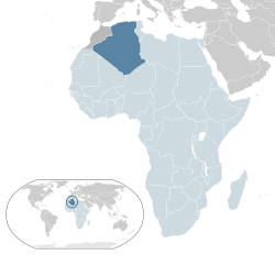 10. Algeria — People’s Democratic Republic of Algeria, is a country in North Africa on the Mediterranean coast. Its capital and most populous city is Algiers. With an area of 2,381,741 square kilometres (919,595 sq mi), 90% of which is desert, Algeria is the tenth-largest country in the world and the largest in the Arab world and Africa. It is bordered to the northeast by Tunisia, to the east by Libya, to the west by Morocco, to the southwest by Western Sahara, Mauritania, and Mali, to the southeast by Niger, and to the north by the Mediterranean Sea.
______________________________________________________
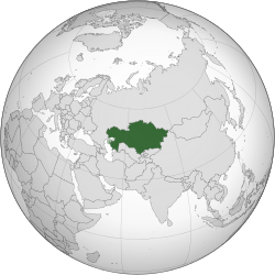 09. Kazakhstan — The Republic of Kazakhstan, is a country in Central Asia, with a minor part west of the Ural River and thus in Europe. Kazakhstan is the world’s largest landlocked country by land area and the ninth largest country in the world; its territory of 2,724,900 square kilometres (1,052,100 sq mi) is larger than Western Europe. It has borders with (clockwise from the north) Russia, China, Kyrgyzstan, Uzbekistan, and Turkmenistan, and also adjoins a large part of the Caspian Sea.
______________________________________________________
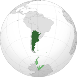 08. Argentina — The Argentine Republic, is a federal republic located in southeastern South America. Sharing the Southern Cone with its smaller neighbour Chile, it is bordered by Bolivia and Paraguay to the north; Brazil to the northeast; Uruguay and the South Atlantic Ocean to the east; Chile to the west and the Drake Passage to the south. With a mainland area of 2,780,400 km2 (1,073,500 sq mi), Argentina is the eighth-largest country in the world, the second-largest in Latin America, and the largest Spanish-speaking one. Argentina claims sovereignty over part of Antarctica.
______________________________________________________
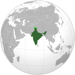 07. India — The Republic of India, is a country in South Asia. It is the seventh-largest country by area, the second-most populous country with over 1.2 billion people, and the most populous democracy in the world. Bounded by the Indian Ocean on the south, the Arabian Sea on the south-west, and the Bay of Bengal on the south-east, it shares land borders with Pakistan to the west; China, Nepal, and Bhutan to the north-east; and Burma (Myanmar) and Bangladesh to the east. In the Indian Ocean, India is in the vicinity of Sri Lanka and the Maldives; in addition, India’s Andaman and Nicobar Islands share a maritime border with Thailand and Indonesia. India (3,287,590 square kilometers). South Asian country that includes most of the Indian subcontinent is the second most populous country in the world (after China) India bordering Pakistan, Nepal, Bhutan, China, Myanmar and Bangladesh.
______________________________________________________
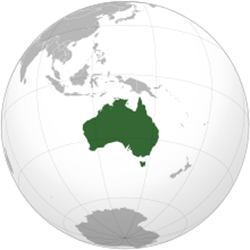 06. Australia — The Commonwealth of Australia, is an Oceanian country comprising the mainland of the Australian continent, the island of Tasmania, and numerous smaller islands. It is the world’s sixth-largest country by total area. Neighbouring countries include Papua New Guinea, Indonesia and East Timor to the north; the Solomon Islands and Vanuatu to the north-east; and New Zealand to the south-east. Australia’s landmass of 7,617,930 square kilometres (2,941,300 sq mi) is on the Indo-Australian Plate. Surrounded by the Indian and Pacific oceans, it is separated from Asia by the Arafura and Timor seas, with the Coral Sea lying off the Queensland coast, and the Tasman Sea lying between Australia and New Zealand. The world’s smallest continent and sixth largest country by total area.
______________________________________________________
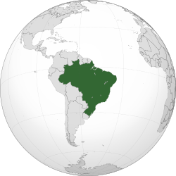
 05. Brazil — The Federative Republic of Brazil, is the largest country in both South America and the Latin American region. It is the world’s fifth largest country, both by geographical area and by population, It is the largest Portuguese-speaking country in the world, and the only one in the Americas. Bounded by the Atlantic Ocean on the east, Brazil has a coastline of 7,491 km (4,655 mi). It borders all other South American countries except Ecuador and Chile and occupies 47.3 percent of the continent of South America. Brazil is the fifth largest country in the world, and third largest in the Americas, with a total area of 8,515,767.049 km2 (3,287,956 sq mi), including 55,455 km2 (21,411 sq mi) of water. It spans four time zones; from UTC−5 comprising the state of Acre and the westernmost portion of Amazonas, to UTC−4 in the western states, to UTC−3 in the eastern states (the national time) and UTC−2 in the Atlantic islands.
______________________________________________________
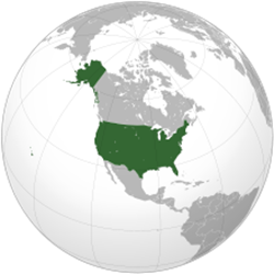 04. The United States of America (USA), commonly referred to as the United States (U.S.) or America, is a federal republic consisting of 50 states and a federal district. The 48 contiguous states and Washington, D.C., are in central North America between Canada and Mexico. The state of Alaska is located in the northwestern part of North America and the state of Hawaii is an archipelago in the mid-Pacific. The land area of the contiguous United States is 2,959,064 square miles (7.7 Mm2). Alaska, separated from the contiguous United States by Canada, is the largest state at 663,268 square miles (1.7 Mm2). Hawaii, occupying an archipelago in the central Pacific, southwest of North America, is 10,931 square miles (28,311 km2) in area.
______________________________________________________
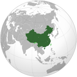 03. China, officially the People’s Republic of China (PRC), is a sovereign state in East Asia. It is the world’s most populous country, with a population of over 1.35 billion. The People’s Republic of China is the second-largest country in the world by land area after Russia, and is either the third- or fourth-largest by total area, after Russia, Canada and, depending on the definition of total area, the United States.China’s total area is generally stated as being approximately 9,600,000 km2 (3,700,000 sq mi). Specific area figures range from 9,572,900 km2 (3,696,100 sq mi) according to the Encyclopædia Britannica, 9,596,961 km2 (3,705,407 sq mi) according to the UN Demographic Yearbook, to 9,596,961 km2 (3,705,407 sq mi) according to the CIA World Factbook.
______________________________________________________
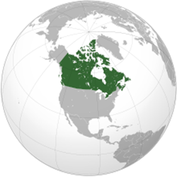 02. Canada, consisting of ten provinces and three territories, in the northern part of the continent of North America. It extends from the Atlantic to the Pacific and northward into the Arctic Ocean, covering 9.98 million square kilometres (3.85 million square miles) in total, making it the world’s second-largest country by total area and the fourth-largest country by land area. Canada’s common border with the United States forms the world’s longest land border. Canada is the second-largest country in the world, after Russia. By land area alone, Canada ranks fourth. The reason why Canada is in 4th place in terms of countries ranked by land area only is because Canada contains 60% of all the lakes in the world. Canada (9,984,670 km²) occupies most of the territory of North America. It bordered to the south by the continental United States. The country stretches from the Atlantic Ocean and the Davis Strait east to the Pacific Ocean in the west. Canada has a reputation for cold country. Indeed, the winters can be harsh in many regions of the country, with risks of blizzards, ice storms and temperatures below -50 ° C in the far north.
______________________________________________________
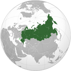 01. Russia, officially known as the Russian Federation, is a country in northern Eurasia. It is a federal semi-presidential republic. At 17,075,400 square kilometres (6,592,800 sq mi), Russia is the largest country in the world, covering more than one-eighth of the Earth’s inhabited land area. Russia is also the world’s ninth most populous nation with nearly 144 million people as at November of 2014. Extending across the entirety of northern Asia and much of Eastern Europe, Russia spans nine time zones and incorporates a wide range of environments and landforms. From northwest to southeast, Russia shares land borders with Norway, Finland, Estonia, Latvia, Lithuania and Poland (both with Kaliningrad Oblast), Belarus, Ukraine, Georgia, Azerbaijan, Kazakhstan, China, Mongolia, and North Korea. It shares maritime borders with Japan by the Sea of Okhotsk and the U.S. state of Alaska across the Bering Strait.


